Python学习|RS Python入门02:列表、字典与流程控制:像元集合的编队【三】条件判断(if-elif-else)
- 2026-09-09 06:22:17
点击上方蓝字 关注我们
2026
在上一课《Python学习 | RS Python 入门 02:列表、字典与流程控制:像元集合的编队【二】》中,我们已经认识了 Python 中最常用的两类容器:列表(list)与字典(dictionary)。
那么诸位现在一定知道,字典(dictionary)基本形式如下:
pixel = {"B1": b1,"B2": b2,"B3": b3,"B4": b4,"B5": b5,"B6": b6,"B7": b7,"sensor": "Landsat8","resolution": 30,"acquisition_time": "2021-07-15"}
而此时,近红外波段的获取方式不再依赖位置记忆:
nir = pixel["B5"]而遥感数据本质上就是一组强语义数据。当我们学会了用字典存数据之后,很快就会遇到几个现实问题:
如果字典里没有某个波段,该怎么办? 如果云量太高,是否应该跳过处理? 如果是 Sentinel-2,用一套流程;如果是 Landsat,用另一套流程? 如果分辨率不符合要求,是否需要重采样?
Part.01
基本语法结构
# 单条件判断if condition:# 条件为True时执行的代码块statement1statement2
# 双分支判断if condition:# 条件为True时执行true_blockelse:# 条件为False时执行false_block
# 多分支判断if condition1:block1elif condition2:block2elif condition3:block3else:default_block
Part.02
缩进的重要性
# 正确示例if True:print("条件成立") # 缩进4个空格print("继续执行") # 相同缩进属于同一代码块
# 错误示例(会导致缩进错误)if True:print("没有缩进") # IndentationError: expected an indented block

Part.03
遥感数据处理中的典型应用
场景一:检查云覆盖率
我们来模拟用一个云量检测流程,输入相关代码如下:
cloud_cover = 25.3 # 云覆盖率百分比if cloud_cover < 10:quality = "Excellent"process_level = "Full"elif 10 <= cloud_cover < 30:quality = "Good"process_level = "Standard"elif 30 <= cloud_cover < 50:quality = "Moderate"process_level = "Basic"print("警告:云量较高,建议人工检查")else:quality = "Poor"process_level = "Skip"print("错误:云量超过50%,跳过处理")print(f"影像质量: {quality}, 处理级别: {process_level}")

场景二:传感器类型判断
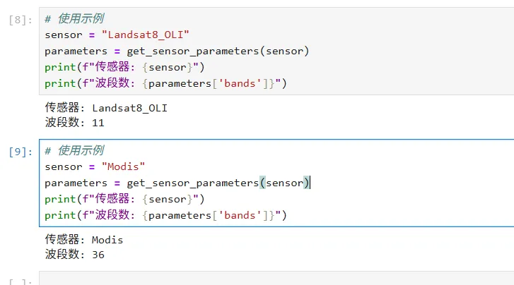
def get_sensor_parameters(sensor_name):"""根据传感器类型返回处理参数"""sensor_name = sensor_name.upper()if "LANDSAT8" in sensor_name or "LANDSAT9" in sensor_name:params = {"bands": 11,"resolution": 30,"radiometric_correction": "LEDAPS","thermal_bands": True}elif "SENTINEL2" in sensor_name:params = {"bands": 13,"resolution": [10, 20, 60],"radiometric_correction": "Sen2Cor","atmospheric_correction": True}elif "MODIS" in sensor_name:params = {"bands": 36,"resolution": [250, 500, 1000],"revisit_period": 1, # 天"swath_width": 2330 # 公里}else:params = {"bands": 1,"resolution": None,"message": "未知传感器,使用默认参数"}print(f"警告:未识别的传感器类型: {sensor_name}")return params
sensor = "Landsat8_OLI"parameters = get_sensor_parameters(sensor)print(f"传感器: {sensor}")print(f"波段数: {parameters['bands']}")
sensor = "Modis"parameters = get_sensor_parameters(sensor)print(f"传感器: {sensor}")print(f"波段数: {parameters['bands']}")
场景三:处理流程控制
或者我们可以模拟一些对影像处理的流程或函数:
def process_remote_sensing_data(image_path, options=None):options = options or {}print(f"开始处理: {image_path}")if not os.path.exists(image_path):print(f"错误:文件不存在 - {image_path}")return Nonemetadata = extract_metadata(image_path)if metadata.get('cloud_cover', 100) > 70:print("云量过高,终止处理")return Noneif options.get('cloud_mask', True):print("执行云检测和掩膜...")image_data = apply_cloud_mask(image_data, metadata)if options.get('atmospheric_correction', True):print("执行大气校正...")image_data = atmospheric_correction(image_data, metadata)if metadata.get('projection') != "WGS84":print("执行几何校正...")image_data = geometric_correction(image_data)print("处理完成")return image_data
Part.04
条件表达式详解
1. 比较运算符
resolution = 30if resolution == 10:category = "高分辨率"elif resolution == 30:category = "中分辨率"elif resolution > 100:category = "低分辨率"else:category = "自定义分辨率"
file_format = "GEOTIFF"if file_format.lower() == "geotiff":driver = "GTiff"elif file_format.lower() == "hdf":driver = "HDF4"elif file_format.lower() in ["jpg", "jpeg", "png"]:driver = "JPEG"else:driver = file_format
ndvi_value = 0.65if 0.6 <= ndvi_value <= 0.8:vegetation_health = "健康"elif ndvi_value > 0.8:vegetation_health = "非常健康"elif 0.3 <= ndvi_value < 0.6:vegetation_health = "中等"else:vegetation_health = "稀疏/非植被"
2. 逻辑运算符
# 组合条件判断is_sentinel = Truehas_cloud_mask = Falsecloud_cover = 15
# and 运算符(所有条件都为True)if is_sentinel and cloud_cover < 20:print("适用于高精度土地覆盖分类")processing_level = "L2A"
# or 运算符(至少一个条件为True)if cloud_cover > 50 or not has_cloud_mask:print("警告:数据质量可能影响分析结果")recommend_check = True
# not 运算符(逻辑取反)if not os.path.exists(output_dir):print("创建输出目录")os.makedirs(output_dir)
# 复杂逻辑组合is_optical = Trueis_thermal = Falseresolution = 30if (is_optical and resolution <= 30) or (is_thermal and resolution <= 100):suitable_for_urban = Trueelse:suitable_for_urban = False
3. 成员运算符与身份运算符
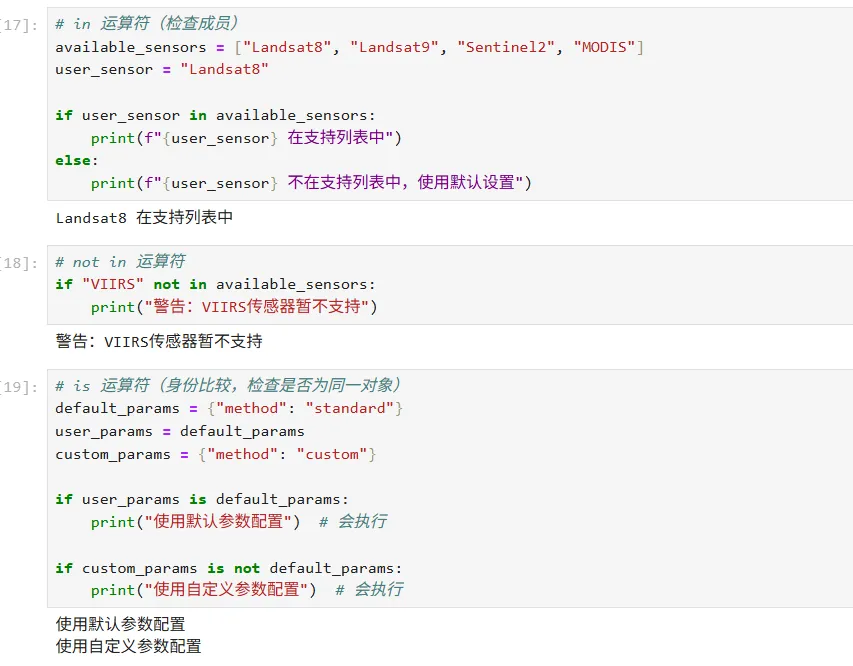
# in 运算符(检查成员)available_sensors = ["Landsat8", "Landsat9", "Sentinel2", "MODIS"]user_sensor = "Landsat8"if user_sensor in available_sensors:print(f"{user_sensor} 在支持列表中")else:print(f"{user_sensor} 不在支持列表中,使用默认设置")
# not in 运算符if "VIIRS" not in available_sensors:print("警告:VIIRS传感器暂不支持")
# is 运算符(身份比较,检查是否为同一对象)default_params = {"method": "standard"}user_params = default_paramscustom_params = {"method": "custom"}if user_params is default_params:print("使用默认参数配置") # 会执行if custom_params is not default_params:print("使用自定义参数配置") # 会执行
Part.05
嵌套条件与复杂逻辑
1. 多层嵌套判断
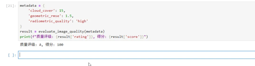
def evaluate_image_quality(metadata):quality_score = 0issues = []# 第一层:基础检查if metadata.get('cloud_cover', 100) < 20:quality_score += 40else:issues.append("高云量")# 第二层:几何质量if metadata.get('geometric_rmse', 10) < 2:quality_score += 30else:issues.append("几何精度不足")# 第三层:辐射质量(嵌套判断)radiometric = metadata.get('radiometric_quality', 'unknown')if radiometric == 'high':quality_score += 30elif radiometric == 'medium':quality_score += 15issues.append("辐射质量中等")else:issues.append("辐射质量未知或较差")# 第四层:综合评级if quality_score >= 80:rating = "A"recommendation = "适用于精密分析"elif quality_score >= 60:rating = "B"recommendation = "适用于常规分析"elif quality_score >= 40:rating = "C"recommendation = "仅适用于粗略分析"else:rating = "D"recommendation = "建议不使用"return {"score": quality_score,"rating": rating,"issues": issues,"recommendation": recommendation}
metadata = {'cloud_cover': 15,'geometric_rmse': 1.5,'radiometric_quality': 'high'}result = evaluate_image_quality(metadata)print(f"质量评级: {result['rating']}, 得分: {result['score']}")
2. 条件表达式(三元运算符)
cloud_cover = 25processing_method = "精细处理" if cloud_cover < 10 else "标准处理"resolution_ratio = 3resample_method = "cubic" if resolution_ratio < 2 else "nearest"ndvi = 0.7land_cover = ("茂密植被" if ndvi > 0.6 else"中等植被" if ndvi > 0.3 else"稀疏植被" if ndvi > 0.1 else"非植被")band_count = len(image_bands)data_type = "multispectral" if band_count >= 3 else "single_band"
Part.06
最佳实践与注意事项
1. 避免过度嵌套
# 不佳的写法(嵌套过深)def process_data_ugly(data, options):if data is not None:if len(data) > 0:if options.get('preprocess'):if options.get('method') == 'standard':# 处理逻辑...passelif options.get('method') == 'advanced':# 处理逻辑...passelse:print("未知方法")else:print("跳过预处理")else:print("空数据")else:print("无数据")
def process_data_better(data, options):# 早期返回,减少嵌套if data is None:print("无数据")return Noneif len(data) == 0:print("空数据")return Noneif not options.get('preprocess', False):print("跳过预处理")return datamethod = options.get('method', 'standard')if method == 'standard':# 处理逻辑...passelif method == 'advanced':# 处理逻辑...passelse:print("未知方法")return datareturn processed_data
2. 使用布尔变量增强可读性
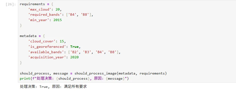
def should_process_image(metadata, requirements):"""判断是否应该处理影像"""has_low_cloud = metadata.get('cloud_cover', 100) < requirements.get('max_cloud', 30)has_georeference = metadata.get('is_georeferenced', False)has_required_bands = set(requirements.get('required_bands', [])).issubset(set(metadata.get('available_bands', [])))is_recent = metadata.get('acquisition_year', 1900) >= requirements.get('min_year', 2000)if has_low_cloud and has_georeference and has_required_bands and is_recent:return True, "满足所有要求"else:reasons = []if not has_low_cloud:reasons.append("云量过高")if not has_georeference:reasons.append("缺少地理参考")if not has_required_bands:reasons.append("缺少必需波段")if not is_recent:reasons.append("数据过时")return False, "; ".join(reasons)
requirements = {'max_cloud': 20,'required_bands': ['B4', 'B8'],'min_year': 2015}metadata = {'cloud_cover': 15,'is_georeferenced': True,'available_bands': ['B2', 'B3', 'B4', 'B8'],'acquisition_year': 2020}should_process, message = should_process_image(metadata, requirements)print(f"处理决策: {should_process}, 原因: {message}")
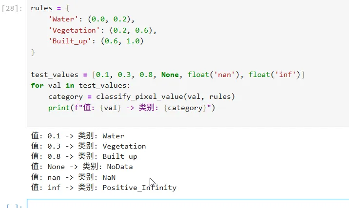
3. 处理边界条件
def classify_pixel_value(value, classification_rules):# 处理None或NaNif value is None:return "NoData"try:value = float(value)except (ValueError, TypeError):return "Invalid"# 处理无穷大if value == float('inf'):return "Positive_Infinity"elif value == float('-inf'):return "Negative_Infinity"# NaN检查import mathif math.isnan(value):return "NaN"# 正常分类逻辑for class_name, (lower, upper) in classification_rules.items():# 处理开闭区间if classification_rules.get(f"{class_name}_inclusive", True):if lower <= value <= upper:return class_nameelse:if lower < value < upper:return class_name# 默认:超出范围return "Out_of_Range"
rules = {'Water': (0.0, 0.2),'Vegetation': (0.2, 0.6),'Built_up': (0.6, 1.0)}test_values = [0.1, 0.3, 0.8, None, float('nan'), float('inf')]for val in test_values:category = classify_pixel_value(val, rules)print(f"值: {val} -> 类别: {category}")
Part.07
总结要点
基础结构:if-elif-else实现多分支逻辑判断
比较运算:使用==, !=, <, >, <=, >=进行数值和字符串比较
逻辑组合:and, or, not运算符实现复杂条件
成员检查:in, not in运算符检查元素存在性
三元表达式:简洁的单行条件赋值
嵌套控制:合理组织嵌套层次,避免过深
早期返回:减少嵌套,提高代码可读性
边界处理:充分考虑None、NaN、边界值等特殊情况
在遥感数据处理中,条件判断是实现质量控制、流程控制、异常处理、自适应算法选择等功能的核心机制,合理运用条件判断可以显著提高程序的稳定适应性。
好了,诸位,我们的条件就讲到这里了,至于策略模式的条件分发、状态机的条件迁移、事件驱动的条件响应……这些进一步的玩法,也就先留一盏灯,改日再同诸位逐层登顶。
如果你觉得“原来Python也能讲得这么遥感”,点个关注,后续系列推文将第一时间推送:
结构、控制流、函数、面向对象……
每一步都用卫星影像、波段、像元做例子,拒绝枯燥抽象。
附赠可运行的 Notebook 源码,自行上传即可上手。本公众号后台回复【RS Python入门02-3】即可获取本节 Notebook 源码。